

FORESTRY
Ninox Robotics' drone services are an excellent solution for remotely surveying and monitoring managed forests. Compared to smaller drone solutions and traditional crewed aviation solutions, our drones are better suited towards collecting data across large areas - providing significant cost savings while still delivering high-quality and actionable information.
With our cutting-edge technology and expertise, we can provide detailed and accurate information that helps our clients make informed decisions, leading to improved productivity and sustainability. Other relevant services for forest management include Fire Management and Biosecurity and Conservation.


Example data
High-Resolution Mapping
Map large areas to assess stock counts and heights, canopy shape & size, and health. Identify problem areas with fallen trees, poor health / growth performance, weed issues, etc.
Try the interactive map and zoom out to see the whole area. Target areas like this do not need to be neighbouring - our solution can string together many distributed plots across a large area in a short time.
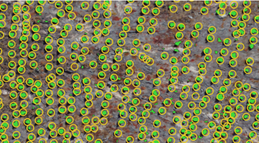
Seedling Assessment
Obtain high-resolution images of seedlings, providing detailed information on the development of individual trees. Seedlings and weeds can be automatically detected, assessed, and marked on a map.
Any issues such as areas of poor performance or weed abundance can be highlighted to facilitate pre-emptive maintenance.
Case Study
HQPlantations: Forest management with the use of drone technology

One of the ≈10,000 high-resolution images captured
HQ Plantations sustainably manages 340,000 hectares of hardwood and softwood forest throughout Queensland, where 2.5 million cubic meters of logs are produced annually. They also protect native forests for the benefit of current and future generations.
We have conducted several photogrammetric aerial surveys over their plantations. In this case study, HQ Plantations required detailed assessment of their stock, including monitoring of saplings. We covered several disjointed areas totalling approximately 17km². Our aerial surveys also detected weeds, allowed stock counts, and assessed infrastructure.
Around 10,000 images were captured from the survey at 3cm/pixel. This imagery was post-processed to deliver a high-quality orthophoto, digital elevation model, and point cloud. We also utilised a proprietary method for automated annotation of 1-4 year old saplings and weeds. HQ Plantations were also able to optimise weed control for different areas with the data we provided.
SUMMARY
Key Points
Image Resolution: up to 1 cm/pixel
Point Cloud Density: up to 30pts/m²
Area Coverage: up to 20 km²/h
Equipment
Phase One iXM-RS150F
Riegl VUX-160
Foxtech Map-A7R IV
Sony A7R
BlueBird SpyLite
If you are interested in utilising our services, or have any questions,
contact us at team@ninox-robotics.com, call 1300 377 977, or request a quote below.